The SLANSW Management Committee recently endorsed a revision of SLANSW regions, based on Local Government Areas. The map and following text, explains the new regions and clearly defines the parameters of each region and the LGAs they fall within.
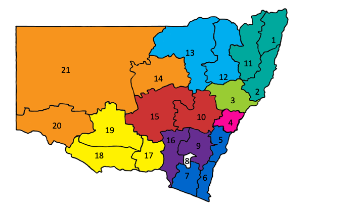
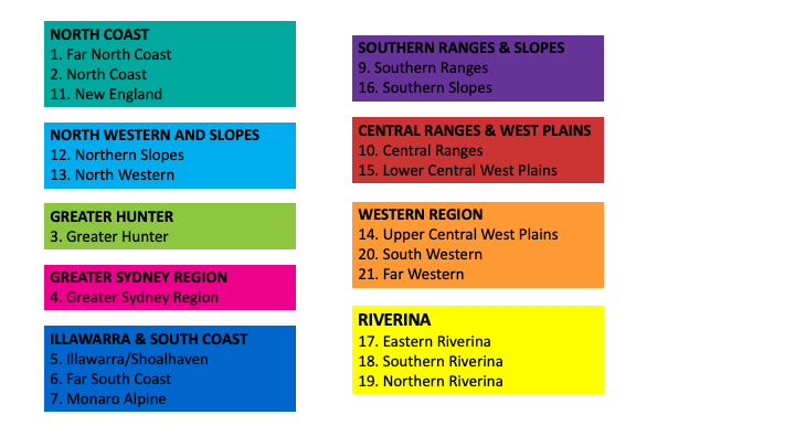 ILLAWARRA & SOUTH COAST, representing areas 5, 6 & 7 on the map.
a. Illawarra / Shoalhaven (5): Kiama, Shellharbour, Shoalhaven, Wingecarribee, Wollondilly, Wollongong
b. Far South Coast (6): Bega Valley, Eurobodalla
c. Monaro Alpine (7): Snowy Mountains
ILLAWARRA & SOUTH COAST, representing areas 5, 6 & 7 on the map.
a. Illawarra / Shoalhaven (5): Kiama, Shellharbour, Shoalhaven, Wingecarribee, Wollondilly, Wollongong
b. Far South Coast (6): Bega Valley, Eurobodalla
c. Monaro Alpine (7): Snowy Mountains
NORTH COAST, representing areas 1,2 & 11 on the map.
a. Far North coast (1): Ballina, Byron, Clarence Valley, Kyogle, Lismore, Richmond Valley, Tweed
b. North Coast (2): Bellingen, Coffs Harbour, Port Macquarie-Hastings, Kempsey, Nambucca, Mid-Coast
c. New England (11): Glen Innes Severn, Tenterfield, Uralla, Walcha, Armidale
GREATER HUNTER, representing area 3 on the map.
a. Greater Hunter (3): Cessnock, Dungog, Lake Macquarie, Maitland, Muswellbrook, Newcastle, Port Stephens, Singleton, Upper Hunter
NORTH WESTERN AND SLOPES, representing areas 12 & 13 on the map.
a. Northern slopes (12): Gunnedah, Gwydir, Inverell, Liverpool Plains, Tamworth
b. North Western (13): Moree Plains, Narrabri, Walgett, Warrumbungle
WESTERN REGION, representing areas 14, 21 & 20 on the map.
a. Upper Central West Plains (14): Bogan, Coonamble, Gilgandra, Warren
b. Far Western (21): Bourke, Brewarrina, Broken Hill, Central Darling, Cobar
c. South Western (20): Balranald, Wentworth
RIVERINA, representing areas 17, 18 & 19 on the map.
a. Eastern Riverina (17): Albury, Coolamon, Greater Hume, Junee, Lockhart, Wagga Wagga
b. Southern Riverina (18): Berrigan, Edward River, Federation, Murray River, Southern parts of Murrumbidgee
c. Northern Riverina (19): Carrathool, Griffith, Hay, Leeton, Narrandera, Northern parts of Murrumbidgee
SOUTHERN RANGES & SLOPES, representing areas 9 & 16 on the map.
a. Southern Ranges (9): Goulburn Mulwaree, Upper Lachlan, Yass Valley, Queanbeyan-Palerang
b. Southern Slopes (16): Cootamundra-Gundagai, Hilltops, Snowy Valleys
CENTRAL RANGES & WEST PLAINS, representing areas 10 & 15 on the map.
a. Central Ranges (10): Bathurst, Blayney, Cabonne, Cowra, Lithgow, Mid-Western, Oberon, Orange
b. Lower Central West Plains (15): Bland, Forbes, Lachlan, Narromine, Parkes, Temora, Weddin, Dubbo
GREATER SYDNEY REGION, representing area 4 on the map.
a. Greater Sydney (4): The Hills, Blacktown, Blue Mountains, Burwood, Camden, Campbelltown, Canada Bay, Fairfield, Hawkesbury, Hornsby, Hunters Hill, Kogarah, Kuring-gai, Lane Cove, Liverpool, Mosman, North Sydney, Parramatta, Penrith, Randwick, Ryde, Strathfield, Sutherland, Sydney, Waverley, Willoughby, Woollahra, Bayside, Canterbury-Bankstown, Central Coast, Cumberland, Georges River, Inner West, Northern Beaches.